I've only just got back from Wales. When down there I stay in a town called Penmaenmawr. It overlooks the A55 Expressway, the main road from Chester to Holyhead. It is just to the west of Conwy and is surrounded by mountains. It even has a railway station though I think only one train a day stops there. The railways first brought appreciable numbers of tourists in the later Victorian period to what was otherwise a quarrying town. The quarry still exists but tourism is something of a shadow of what it used to be. Nevertheless, the town has had at least one famous regular tourist visitor who left his mark, or at least his statue. Victorian Liberal Prime Minister William Ewart Gladstone's statue was paid for by public subscription and erected in 1898, after this dominant figure of Victorian British politics died (can you imagine people in 21st century Britain subscribing to a statue of a modern politician!?)
Though Penmaenmawr's number of visitors is not what it was decades ago, in some respects, that adds to the attraction of the place. You will not be jostling with other tourists in the town.
This is a town to visit if you like stunning scenery. The town spreads up the lower reaches of the surrounding hills. Go up to the top of the town and have amazing views out to Anglesey and Puffin Island towards the west, Conwy Bay and the Irish Sea to the North and the Great Orme at Llandudno to the east. If you go high enough up into the hills, on a clear day you can see the Isle of Man. And if you fail to see the Isle of Man, you may see the wild horses that live up here instead.
For the walkers amongst you, use Penmaenmawr as a base and head for the hills. If you visit the town, you will understand why I return to it so often.
The one significant drawback is the A55 Expressway itself. The original route for the main North Wales route was through the town itself, along Bangor Road. The building of the road has removed the heavy traffic from the town. The resulting Expressway however demolished the Edwardian promenade and has sliced a concrete and tarmac scar between the town and the beach. You can see it from the pictures below I took from the hilltop overlooking the town.
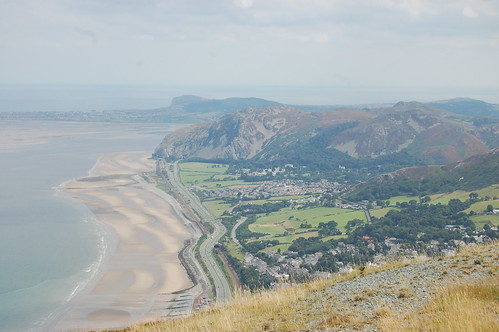
In the above picture, you can get an idea of the views available to people taking a walk in the surrounding hills. In the distance is Llandudno. However, note the Expressway dividing the beach from the town (there is a subway through to the beach).
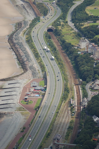
This photo gives a better view of the Expressway. It's the one blot on the landscape though building it has ensured the centre of the town is not destroyed by thousands of vehicles rumbling through each day. If anything, it has made for a peaceful town centre.
Don't let the Expressway put you off the beach however. The road is shielded and so you can barely hear the noise of traffic once you are on the sand. The following video gives some idea of the beach at low tide.
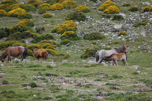
Look out for the wild horses whilst walking on the hills. You can also see them in the following video. Note also the hill and mountain scenery in this video. Also included is the Druid's Circle, a circle of stones laid down in the second millennium BC.
I've plenty more photos of Penmaenmawr, including loads from my trip over the weekend just gone which I haven't sorted yet. I'll try to post them up soon.
No comments:
Post a Comment